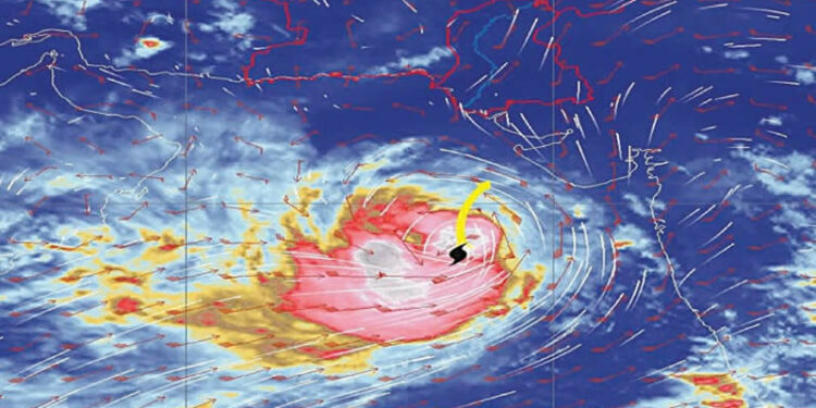
Cyclone Biparjoy has turned into an “extremely severe cyclonic storm” and is very likely to cross over the area between Pakistan’s Keti Bandar and Indian Gujarat on June 15, the Pakistan Meteorological Department (PMD) stated on Sunday.
The system is located at a distance of 690km south of Karachi, 670km south of Thatta and 720km southeast of Ormara, according to PMD’s advisory released on Sunday at 9.45pm.
In a related guideline, Pakistan Civil Aviation Authority’s airside department has alerted the relevant officials to ensure safety of lightweight aircraft and other electrical equipment by taking precautionary measures such as mooring of parked light aircraft or re-parking to a safer place.
Also, due to the risk of collision, goods near the runways and tarmac area in Karachi should be moved to a safer place, it has advised.
Area between Keti Bandar, Indian Gujarat seen as most vulnerable
The National Disaster Management Authority (NDMA), in coordination with PMD, provincial disaster management authorities (PDMAs) of Sindh and Balochistan, Pakistan Navy, Pakistan Maritime Security Authority, Pakistan Coast Guards, has been issuing advisories and guidelines to all stakeholders at national and provincial levels to undertake proactive preparedness and mitigation measures.
“#Biparjoy Cyclone is unpredictable yet categorised as high intensity. Panic is counterproductive but caution and planning are better than being caught unawares,” tweeted Minister for Climate Change and Environmental Coordination Sherry Rehman, advising all relevant departments of Sindh and Balochistan to be on ‘high alert’.
“The cyclone over the east-central Arabian Sea has maintained its intensity over the past 48 hours and tracked northward. In fact, every 12 hours, wind’s intensity around the system’s centre is increasing by [a speed of] 30km to 40km an hour due to favourable environmental conditions,” chief meteorologist Dr Sardar Sarfaraz told Dawn.
Currently, he said, the area of about 250km located between Keti Bunder and the Indian Gujarat was ‘most vulnerable’, though the adjoining areas would also experience the system’s influence.
Intensity, direction
“The cyclone is very likely to reduce its intensity, turning into a very severe cyclonic storm from an extremely severe storm as is the situation right now, between June 13 and June 14 as it would get close to land. During this time, it’s expected to change its direction, too, and track northeastward. High winds are likely to start blowing from the night of June 13 onwards,” the top weatherman pointed out.
The ‘slight’ loss in cyclone’s intensity would happen due to unfavourable conditions such as sea surface water getting cooler and wind shear getting strong, he explained.
He said a 2021 cyclone crossed over the Indian Gujarat and brought dust storm and high winds to lower Sindh, including Karachi, but “this time, Karachi may see moderate spell with isolated heavy falls. Localised flooding can’t be ruled out given the state of drainage system in the city, apart from other potential damages.”
According to the department’s alert, the system has moved further northward during the last 12 hours and now lies near Latitude 18.7°N & Longitude 67.8°E.
The maximum sustained surface winds are 180-200km per hour and gusts 220km per hour around the system centre and sea conditions being phenomenal around the system centre with maximum wave height 35-40 feet. Favorable environmental conditions (sea surface temperature of 30-32°C, low vertical wind shear and upper-level divergence) are supporting the system to maintain its severity.
“Under the existing upper-level steering winds, Biparjoy is most likely to track further northward till June 14 morning and then re-curve northeastward and cross between Keti Bandar (southeast Sindh) and Indian Gujarat coast on June 15 afternoon as a very severe cyclonic storm,” the advisory says.
Thatta to Umerkot
The department has warned of widespread wind-dust/thunderstorm rain with some very heavy/extremely heavy falls accompanied with squally winds of 80-100km/hour likely in Thatta, Sujawal, Badin, Tharparkar and Umerkot districts during June 13-17.
“Dust/thunderstorm-rain with few heavy falls and accompanied with squally winds of 60-80km per hour likely in Karachi, Hyderabad, Tando Mohammad Khan, Tando Allayar, Mirpurkhas districts from June 13/14 till June 16.
“High intensity winds may cause damage to loose and vulnerable structures (Kutcha houses). Storm surge of 3-3.5 meters (8-12 feet) is expected at the land falling point (Keti Bandar and around).
It advised fishermen not to venture in open sea till the system is over by June 17, as the sea conditions may get very rough/high accompanied with high tides along the coast.
In a statement, the NDMA said its national emergency operations centre was continuously monitoring and sharing information with all stakeholders and public through webpage-based projections of tropical cyclone Biparjoy’s tracks and impacts on coastal areas. The leading federal agency that deals with disaster management urged public to stay informed and follow the official updates and warnings issued by relevant authorities to protect themselves and their properties from the possible impacts of the cyclone.
Gwadar
In view of the ‘rising threat’ of cyclone in the coastal areas of Balochistan, the PDMA, Gwadar deputy commissioner and other district officials in a meeting decided to impose a complete ban on going towards the coastal area and declare emergency in hospitals.
To monitor the situation and deal with any untoward incident promptly, the Gwadar administration also set up a control room.
The district administration decided to ban fishing, warning fishermen not to venture in open sea during the forecast period. The PDMA directed local authorities to coordinate with relevant line departments and municipal administrations to secure boats of the fishermen, and remove hoardings in view of strong winds.
At the meeting, PDMA director general Jahanzeb Khan reviewed arrangements and said a plan was prepared in view of the forecast.
Aviation
In view of PMD’s forecast that the cyclone was heading towards Karachi, the Civil Aviation Authority’s airside department issued a safety guideline.
Besides moving goods away from the runways and tarmac area to a safe place and mooring of parked light aircrafts or re-parking to a safer place, following precautionary measures have been recommended due to the forecast of rain with gusty winds:
Staff should ensure that beacon lights over high-rise buildings, mobile towers, flood lights and advertisement boards should be properly intact to avoid any incident.
Team should be ready to determine friction/braking action of runway for safe aircraft operation during rain. Cleaning of all water drains / nullahs be ensured especially behind the international and domestic satellite area before monsoon for smooth flow of rainwater.


